Current Research
NSF-EarthCube: Collaborative Proposal: Brokered Alignment of Long-Tail Observations (BALTO)
Limited access to hidden long-tail observations collected and produced by domain scientists can hinder scientific advances towards tackling the challenges of understanding and predicting a complex and evolving solid Earth, hydrosphere, atmosphere, and space environment systems? (EarthCube mission). To facilitate access to long-tail observations this work proposes a core capability for the future EarthCube (EC) architecture proposed in the Architecture and Implementation Plan – Brokered Alignment for Long- Tail Observations (BALTO). BALTO entails an open-source interface to discover, access and transform geoscience data sources through a brokering solution implemented by user-developed accessors. BALTO integrates core attributes of successful prior EC Building Blocks, BCube and ODSIP, to create a next generation EC capability. Leveraging its large installed base and its open-source flexibility, BALTO will extend Hyrax OPeNDAP’s data server for ODSIP with capabilities for distributed brokering. Results from this project will demonstrate improved access and its impacts on scientific discovery via three NSF funded interdisciplinary use-cases that span geodesy, seismology, hydrology, oceanography, and geodynamics. Geoscientists leading the use-cases will specify the data-access needs BALTO must fulfill, and they will demonstrate its utility to address scientific questions posed in their funded projects through the use of their custom accessors that utilize the data access protocol central to BALTO.
USDA-Development and Evaluation of Market-like Pay-for-Performance Programs to Address Legacy Nutrients
Excess nutrient loads are the leading obstacle to achieving water quality goals in the Chesapeake Bay. While state and regional efforts have reduced nutrient loads, substantial quantities of nutrients, called legacy nutrients, remain temporarily stored in soils and groundwater. The release of these stores of nutrients into surface water can delay achievement of water quality objectives. Market-like programs create direct financial rewards for nutrient reductions. Most agricultural payment for service incentive programs, including most existing nutrient trading programs, are based on modelled water quality outcomes from different agricultural management practices. Payments for demonstrated performance (PDP) (or measured load reductions), however, are rare due to the implementation challenges associated with agriculture nonpoint source discharge. The overall goal is to design and test PDP nitrogen reduction contracts between buyers of nutrient reductions and agricultural landowners for an innovative technology, denitrifying bioreactors, to reduce legacy nutrients. PDP incentive programs to address legacy nutrients offers a compelling opportunity to advance the design of market-like incentive systems, remove large quantities of nitrogen in a single treatment, increase certainty in achievement of water quality outcomes, and provide low cost options for potential buyers of nutrient reductions. The project will develop and evaluate quantification protocols to directly monitor and measure nitrogen removal at project test sites. The project will develop PDP contracts that compensate landowners on observed nutrient reduction removal success and creates incentives to actively manage bioreactors to maximize removal performance and lower costs.
Assessment of regional spring discharge (a) NO3 concentration (b) and flux (c).
NSF-WSC-Category-1: Collaborative Proposal: Coupled Multi-scale Economic, Hydrologic, and Estuarine Modeling to Assess Impacts of Climate Change on Water Quality Management
Key Collaborators: Ray Najjar (Penn State), Ming Li (UMD-CES), David Sample (VT), Darrell Bosch (VT)
The overarching goal of this project is to develop a quantifiable, predictive framework that couples biogeochemical and hydrologic drivers of terrestrial nutrient export with climate change to evaluate the effects of ecosystem management on estuarine function and costs of water quality protection. To achieve this goal, we propose to work broadly across common regional Chesapeake Bay watershed physiographic gradients and dominant landuses (e.g., agriculture, forest and urban). The following goals will allow us to develop a this framework based on our best current knowledge, explore the impact of climate change and extreme weather events on nutrient and sediment export, and develop new modeling paradigms (Fig. 1) to improve water quality models used for management decisions.
- Bracket the mid-century changes in climate for the Chesapeake Bay watershed with downscaled high-resolution regional climate models.
- Evaluate likely changes in landscape patterns and magnitudes of N and P cycling and erosion using downscaled climate model outputs coupled to multi-scale landscape models.
- Investigate how climate change and alternative nutrient management strategies affect water quality in the Chesapeake Bay.
- Assess tradeoffs between costs of Best Management Practices (BMPs) and landscape management intended to control nitrogen (N) loadings and variability of N loadings under alternative climate change scenarios
Framework for modeling analysis
NSF-WSC-Category-3: Collaborative Proposal:Impacts of Climate Change on the Phenology of Linked Agriculture-Water Systems
Key Collaborators: Bill Ball and Ciaran Harman (JHU), Lisa Wainger, William Kemp, Jeremy Testa and Laura Murray (UMD-CES), Jim Shortle (Penn State), Ariel Ortiz-Bobea (Cornell), Damian C. Brady, (Univ, Maine)
Our proposed research is based on the premise that climate induced changes in the timing of agricultural practices that may seem insignificant when analyzed in isolation have the potential to create disproportionately large effects on downstream watersheds and ecosystems due to their interactions with other climate induced changes. Our objective is to explore various aspects of this premise and, in the course of so doing, to develop new approaches and understanding of the following four research elements of the system, and the links between them. Here, we seek improved understanding of:
1. How a change in climate affects farmers’ decisions about land use and timing of agricultural practice (human phenology);
2. How a change in climate, agricultural practice, and land-use affects watersheds’ intra-annual variability of water, sediment, and nutrient export (watershed phenology);
3. How changes in timing, location, and watershed inputs affect estuary physical and biological response, including the severity of hypoxia (estuarine phenology); and
4. How policy designed to influence agricultural land use and practice to mitigate ecosystem impacts can account for these cascading human, biological, and physical effects in water systems.
NSF EarthCube Building Blocks: A Broker Framework for Next Generation Geoscience
Key Collaborators: Univ. of Colorado, J&F Enterprise, Oak Ridge National Laboratory, Scripps Institute of Oceanography, Univ. of California at San Diego and at Irvine, Univ. of Texas, Boston University, Oregon State University, Rutgers, Woods Hole Oceanographic Institute, National Center for Atmospheric Research
EarthCube Building Blocks: A Broker Framework for Next Generation Geoscience which addresses the need for effective and efficient multi-disciplinary collaboration through the introduction of brokering as an EarthCube building block. The need for expanded collaboration has increased as science addresses the complex challenges of understanding and predicting Earth’s environment. The issues, identified as Grand Challenges by the NSF in their GEOVision report, are: “Understanding and forecasting the behavior of a complex and evolving Earth system” and “Reducing vulnerability and sustaining life.” This same report highlights that an “integrated and interdisciplinary approach in the geosciences will lead to new paradigms for human interactions with the Earth and guide us to solution-oriented applications.” EarthCube (EC) is the NSF GEO flagship initiative identified in the GEO Vision to create a new generation of information infrastructure. EC aims to transform the conduct of research through the development of community-guided cyberinfrastructure to integrate information and data across the geosciences.
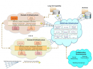
Proposed Earth Cube architecture.
Decreasing Nitrogen and Phosphorus in Drainage Waters Using a Comprehensive Drainage Management Approach
Key Collaborators: Univ Maryland Eastern Shore, Univ Delaware, USDA-ARS Pasture Systems and Watershed Management Research Unit, Penn State
Controlling nutrient loss from artificially drained agricultural lands on the Atlantic Coastal Plain requires a comprehensive approach that includes field and drainage management practices to address production and water quality concerns. Previous research by the project team has demonstrated significant nitrogen (N) and phosphorus (P) reduction with conventional and novel management practices, e.g., flow control structures, gypsum curtains, biofilter reactors. This project seeks to integrate field and drainage management practices to develop, demonstrate and test a comprehensive approach to drainage management that can be readily adopted by producers on the Coastal Plain.
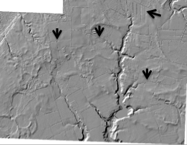
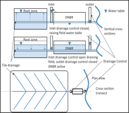
Top image, LIDAR used to identify drainage connectivity and outfall, and for prioritizing drainage management. Bottom image, schematic of biofilter reactor to intercept drained field flow.
Regional Climate Change in the Blue Nile Basin Ethiopia: Implications for Water Resources and Sediment Dynamics
Key Collaborators: Abay Basin Authority, Beles Subbasin Organization, Tana Subbasin Organization; International Water Management Institute; Canadian International Research Development Center
This project focuses on determining the potential impact of climate change on water availability and land degradation in the Blue Nile Basin. As much as 90% of the Nile River flow that reaches Egypt originates in the Highlands of the Ethiopian Blue Nile Basin. This imbalance in water availability poses a threat to water security in the region, and could be severely impacted by projected climate change. This analysis coupled hydrodynamic/watershed models with the Intergovernmental Panel on Climate Change (IPCC) AR4 climate change scenarios to assess the potential impact on water resources and sediment dynamics. Specific AR4 scenarios include the A1B, B1, B2 and COMMIT, which were used to force the baseline hydrodynamic models. Model results indicate that the Tana basin is expected to experience an increase in mean annual flow. The Beles basin is predicted to experience a small decrease in mean annual flow. Sediment concentrations in the Tana basin increase proportionally more than the flow increase. Interestingly, and perhaps counter to what might be expected for a decrease in flow in the Beles basin, sediment concentrations increase.
We will also be assessing the impact of climate change on field level response using this framework. We will assess the predictions at the field scale in sub sections of the two basins by comparing the patio-temporal changes in runoff generation, evapotranspiration, erosion, and soil water content against baseline model predictions. This analysis will inform stakeholders about the impact of climate change on agricultural productivity in the rain fed Ethiopian Highland system.
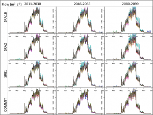
Climate change scenario analysis results for discharge for the Tana basin. The black lines are the base model projections.
A Coupled Biochemical/Biophysical System to Remediate Diffuse Nitrate in Shallow Groundwater
Key Collaborators: USDA (Pete Kleinman); Cornell University (Larry Geohring); Shimadzu (Paul Macek)
The goal of this project is to develop a system, consisting of several components that is capable of permanently removing N from GW. The proposed work is novel in the respect that it couples several seemingly disparate technologies (e.g., facilitated microbial denitrification, biomass harvesting, pyrolysis, and pyrolysis co-product, Biochar reincorporation) that together have the capacity to remove as much as 90% of the NO3- and 45% of soluble P from shallow GW.
As part of this work Emily Bock working with analytic chemists has developed a method to detect and quantify trace gas emission from the bioreactors. This method can measure Noble and Green House Gases at sub atmospheric concentrations.
Refining P Indices in the Chesapeake Bay Region to Improve Critical Source Area Identification
Key Collaborators: USDA (Pete Klienman, Tony Buda, Amy Collick); Penn State (Doug Beegle); West Virginia Univ (Joshua Faulkner).
Despite the apparent success of the P Index concept, there remain concerns about the effectiveness of the Indexing approach for attaining water quality goals. One of the major concerns that has been raised is that the transport component of many P indices is either not well developed, or unimportant (i.e., in some P Indices the transport scales from 0 to 1 and the source from 0 to 100 or more). Our regional project seeks to refine P management via the P Index concept, specifically:
- Evaluate P Indices by comparing their output with water quality monitoring data and fate-and-transport models.
- Use water quality data (monitored or predicted by model) to refine P Indices, improving their prediction of P loss potential, ensuring consistency across state boundaries and within physiographic provinces, and promoting effective recommendations for P management.
- Predict the management impact of P Indices on nutrient management practices and water quality.
21st Century Water Protection Tools
Key Collaborators: Cornell University (Todd Walter), UVM (Joshua Faulkner)
This project aims to develop and implement a decision support system that will forecast runoff risks (6-hrs to 3 days) across portions of the Chesapeake Bay watershed. These risks will be displayed on Google-map-like images accessible via the Internet (e.g., via smart phones and GPS enabled devices). The intent is to provide information for land management decision-making to reduce nonpoint source pollution risks. Although the focus is on agricultural management activities like manure spreading, choosing conservation reserve parcels, designing riparian buffers, its applications are clearly broader. It is expect that this tool will result in reduced non-point source pollutant loads from storm runoff, which will ultimately improve water quality throughout the watershed and receiving waters. Also, because the tool developers and stakeholders are directly connected, there will be novel opportunities for on-going adaptive tool development in collaboration with stakeholders evolving needs and new scientific discoveries.

Watershed stakeholder decision support system architecture. Development of Open Source “Community Hydrologic Models” in R
“EcoHydRology” and “SWATmodel”, available from the CRAN Repository (see Software Page).
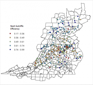
SWATmodel results for 314 USGS stream gauges in the Chesapeake Bay (Fuka et al., 2014, JAWRA).